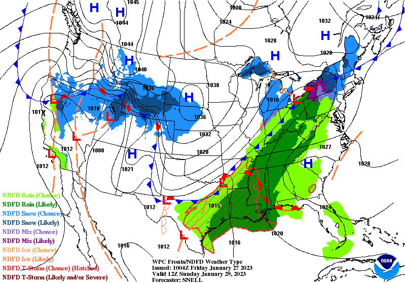
The final few days of January will feature numerous chances for snowfall across the northern half of the country and mountainous West, with potentially heavy snow leading to travel impacts as bitter cold temperatures surge into more the Nation by the end of the weekend. An initial system traversing the Upper Midwest and Upper Great Lakes this morning will be responsible for light to moderate snowfall and gusty winds throughout the region into tonight. An arctic front will push into the Northern Plains today, moving further into souther states over the weekend.
Winter Weather Advisories and Blizzard Warnings have been issued through midday across the Red River Valley of the North due to additional snow and blowing snow. To the west, a strong arctic cold front pushing south into the northern Rockies will allow for conditions favorable for periods of heavy snow across much of the northern High Plains and central/northern Rockies through this weekend. Snow could be heavy at times and drastically reduce visibility, making travel potentially treacherous. A wave of low pressure forming along the aforementioned frontal boundary is expected to swing eastward tonight into the central Plains and eventually into the Midwest on Saturday.
A swath of moderate to locally heavy snow is forecast to the north of this low, stretching from the Black Hills to southern Michigan. The heaviest snow associated with this system is anticipated to occur from the North Dakota-Nebraska border to the northern half of Iowa, where over six inches of snow is possible along a narrow corridor.
An arctic airmass lurks over much of central and western Canada this morning and will dive southward behind the sinking cold front this weekend. Temperatures 20 to 40 degrees below average are forecast to spread into the northern Rockies and northern/central Plains by Sunday, with highs only reaching into the single digits and lows dropping into the minus teens. Gusty winds will make it feel even colder and could lead to dangerous conditions for individuals spending an extended amount of time outdoors.
Elsewhere, as this same frontal boundary approaches the Deep South on Sunday and stretches northeastward into the Lower Great Lakes, numerous showers and thunderstorms are expected. The cold front is forecast to act as a focus for moisture as a warm and muggy airmass surges back northward out of the Gulf of Mexico, which may lead to thunderstorms capable of containing intense rainfall rates. A Slight Risk (level 2/4) of Excessive Rainfall has been issued from the Upper Texas Coast to the South Carolina Lowcountry, where there exists the best chances for several inches of rain that could lead to scattered flash floods.